


SATIM Monitoring Satelitarny Sp. z o.o.
- Królewska 65, 30-081 Kraków, Poland
- hello@satim.co
- satim.co
Description
SATIM | Automated SAR Analysis for Sovereign ISR. Any Sensor. One Standard.
SATIM builds software that turns Synthetic Aperture Radar data into actionable intelligence — regardless of weather, daylight or sensor provider. Radar sees through cloud and darkness, yet interpreting radar imagery remains one of the hardest problems in modern reconnaissance. SATIM's algorithms solve it: they automatically detect and classify objects – vessels, vehicles and aircraft – compressing the path from image to decision from hours to minutes.
Founded in Kraków, Poland, the company grew out of a research environment specialising in radar signal processing. Today it combines remote sensing, machine learning and defence intelligence expertise across its headquarters in Kraków and offices in the Great Britain and the United States.
SATIM works with leading European and global defence and space organisations, including Rheinmetall, Thales, the European Space Agency, IMSAR, TII, and Airbus, as well as SAR constellation operators such as ICEYE, Synspective, Umbra, Capella Space and Ursa Space Systems. The company's technology supports satellite reconnaissance programmes serving NATO member and allied armed forces.
We invite you to discuss the application of automated SAR analysis in maritime domain awareness, critical infrastructure protection and monitoring of military activity.


Download
-
From-Image-to-Operational-Effect-SATIM-White-Paper-2026-compressed.pdffile size: 4.39 MB
Products
OREC
OREC
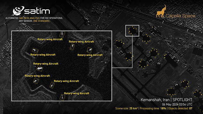
OREC is the analytical layer for sovereign SAR-based ISR. It sits between radar sensors and the systems the user already operates: it ingests imagery from any source, automatically detects and classifies objects — vessels, ground vehicles and aircraft — and passes the result on ready to be acted upon.
Instead of reviewing scene after scene by hand, the analyst receives detections carrying an object location, class and a confidence level. The path from acquisition to decision shortens from hours to minutes.
Role in the architecture: an analytical layer between SAR sensors and the user's intelligence and command systems; one exploitation chain for every imagery source.
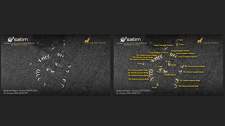
Input data: imagery from commercial and government satellites and from UAV platforms; support for SLC and GRD products and for Dwell, Dwell Fine, Spotlight, Stripmap and Scan modes; sensor-agnostic architecture with no dependency on a single constellation operator.
Analysis: automated detection and classification of objects: 263 vessels, 28 aircraft, 12 vehicles; classification accuracy of up to 95%.
Processing: a fully automated chain from scene calibration to analytical result, with no operator in the loop; per-scene processing measured in minutes.
Output: geolocated detections carrying object class, confidence level and geometric parameters; data ready for use in GIS environments, analytical tooling, and command systems.
Deployment: cloud, edge, on-premise and air-gapped environments.

OREC-Intelligence
OREC-Intelligence
OREC-INTELLIGENCE is an ISR intelligence system built on the OREC engine for persistent monitoring of designated areas of interest. Incoming SAR acquisitions are analysed automatically, and results reach the operator as alerts on detected objects and changes in the situation.
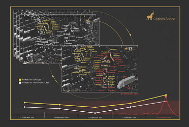
The system aligns detections over time, building a picture of normal activity in the area and surfaces anomalies, such as new units appearing or leaving, activity in previously quiet locations.
The analytical team moves from reviewing hundreds of scenes to working the events that actually warrant attention. OREC-INTELLIGENCE supports maritime domain awareness, critical infrastructure protection and monitoring of military activity, including in areas optical observation cannot serve.
rchitecture: an intelligence layer built on the OREC analytical engine, using the same sensor-agnostic chain for detection and classification of maritime, ground and air objects.
Monitoring: definition of areas of interest and observation schedules; automated ingestion and processing of incoming imagery from connected SAR data sources; continuous operation with no operator in the loop.
Analysis: detections aligned into time series; change detection and identification of departures from the user-defined activity pattern; observation history for objects and areas.
Outputs: alerts on detected objects and events, generated in near real time; geolocated detection layers and situational reports for the area.
