"Uniforce" sp. z o.o. sp.k.
- ul. Bodawska 11, 61-309 Poznań, Poland
- +48 61 875 04 76
- kontakt@uniforce.pl
- www.uniforce.pl
Description
As Uniforce, we provide and implement state-of-the-art solutions for unmanned aerial systems (UAS), electronic and optoelectronic security systems, video analytics and tactical vision systems. We support customers at all stages, from design to implementation to operations.
Since 2007, we have earned the trust of many customers - the military, uniformed services, state-owned companies, private companies and security system integrators.
One of our areas of specialisation is drone-based solutions. We offer professional unmanned aerial systems, fielded by the uniformed services of many countries, including fire brigades and rescue units, using advanced optical and thermal imaging cameras. We offer both drones performing LOS and BVLOS flights, as well as non-piloted tethered systems.
At IFRE, we will be showcasing solutions from, among others:
- Skydio: American drone manufacturer renowned for its advanced flight autonomy (including automatic obstacle avoidance), based on artificial intelligence
- Atlas Aerospace: a Latvian manufacturer of drones operating in a MESH network, which significantly increases the operational capabilities of the system, including reducing the impact of terrain obstacles on radio range and with a vehicle-ready docking station, enabling take off and landing on a moving vehicle,
- Reveal: a manufacturer of photogrammetric software that enables the near-realtime generation of 3D models of terrain (including structures) based on video, photos or stream from a drone; the software runs on Android mobile devices and Windows and Linux computers
- Autel: one of the drone market leaders, with a very strong professional platform segment, with advanced optics and thermal imaging and AI-based image analysis
- Fotokite: Swiss manufacturer of tethered drones, available as a portable [‘in- case’] model, for mounting on the roof of a car or integrated into fire engines
- Hoverfly: manufacturer of tethered drones from the USA, featuring high payload (cameras and radios) capacity (up to 3.5 kg)
Uniforce has been awarded ISO 9001:2015, ISO/IEC 27001:2022 and AQAP 2110:2016 certifications.


Products

AtlasPRO UAS
AtlasPRO UAS
AtlasPRO is an all-weather sUAV, designed primarily for ISTAR missions up to 16 km BVLOS. A distinguishing feature of Atlas solutions is the rich ecosystem of MESH-networked devices, which greatly enhances its operational capabilities - enabling complex missions, effectively increasing radio range and reducing the impact of terrain obstacles on transmission.
Interchangeable payloads (with optical, thermal and dual cameras) allow the drone to be customised for different types of missions. The Atlas also features exceptionally strong interference resilience, field-proven in Ukraine, thanks to smart frequency hopping. The control apparatus allows for cable connection to an external transmitter, increasing operator safety.
UAV dimensions (without propellers)
- Assembled: 417 x 323.5 x 115.5 mm
- Unfolded: 445 x 557.5 x 185.5 mm
Weight (excluding batteries and payload): 1050 g
Weight (with battery, without payload): 1585 g
Maximum take-off weight: 1900 g
Maximum payload: 315 g
Operating temperature range (optional): -20°C to +55°C (-30°C +50°C)
Ingress protection: IP54
Operating frequency: 2.4 - 2.4835 GHz; 2.2 - 2.7 GHz
RF output power: 30 dBm
Antenna gain: 3 dBi
GNSS: GPS + GLONASS + Galileo
Hovering accuracy (GPS mode): 0.5 m - 2.5 m
Downward-facing rangefinder: ToF LIDAR
- Field of view: +/- 1.7 degrees of cone beam
- Obstacle detection range: 20 m
Noise level: 56 dBa at 15 m
Maximum tilt angle: 45 degrees
Max. climb rate: 5 m/s
Max. descent speed: Variable, 1.5 - 3.5 m/s
Maximum control speed: 56 km/h
Maximum speed (with payload):
- Standard propellers: 56 km/h
- Silent propellers: 46 km/h
Max wind resistance: 15.5 m/s (56 km/h)
Max flight time (with payload): 40 min
Max flight distance: 16 km
Max ceiling: 3000 m above sea level
Propeller dimensions:
- Standard propellers: Length: 30.5 cm. Weight: 12.2 g
- Silent propellers: Length: 33.2 cm. Weight: 15.8 g


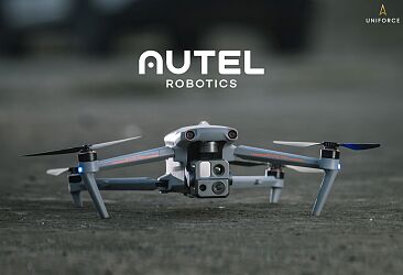
Autel Alpha UAS
Autel Alpha UAS
The Autel Alpha is a highly advanced drone for multiple applications, including industry, law enforcement and search&rescue.
It delivers exceptional performance with autonomous flight, obstacle avoidance, high quality video transmission and battery capacity. Thanks to its foldable design and IP55 protection rating, it can handle even the harshest environments.
The built-in dual RTK antenna system ensures millimetre-level precision in flight. With the new generation DG-L35T gimbal, the drone integrates a hybrid camera with 560x zoom, two thermal imaging cameras, a visible light wide-angle camera and a laser rangefinder. The dual thermal imaging camera will find use in both short-range inspection and long-range detail observation, providing a more professional and comprehensive solution for applications such as public safety, energy inspections and emergency response.
DRON
Weight (with battery, gimbal and propellers): 6340 g
Dimensions: 1205x980x278mm (unfolded, with propellers), 780x568x278mm (unfolded, without propellers), 455x263x248mm (folded, without propellers)
Flight time: up to 40 min.
Max. horizontal flight speed: 25m/s
Wind resistance: 12m/s
Operating frequency: 2.4 GHz / 5.2 GHz / 5.8 GHz / 900 MHz
Protection class: IP55
Max. transmission range: 15 km
GNSS: GPS / GLONASS / BDS / Galileo
ZOOM CAMERA
Matrix: 8MP
Optical zoom: 35x
Hybrid zoom: 560x
ISO up to 160,000
WIDE-ANGLE CAMERA
Matrix: 48MP
Aperture: f/2.8
35 mm focal length equivalent: 24mm
DUAL THERMAL IMAGING CAMERA
Resolution: 640x512
Hybrid zoom: 56x
Wide angle lens: 13mm
Standard lens: 45 mm


Autel Evo Max 4T UAS
Autel Evo Max 4T UAS
The Autel Evo Max 4T is a design with impressive capabilities: advanced optics and thermal imaging are supported by intelligent image analysis algorithms. Applications for the drone include rescue missions, remote inspection or 3D modelling.
The EVO Max series uses Autel Autonomy autonomous flight technology, offering global route planning, autonomous obstacle avoidance and return to take-off in complex environments. It also offers precise visual navigation in scenarios where GNSS signals are blocked, weak or highly distorted. A-Mesh technology supports the free networking of multiple devices, providing integrated ground-to-air network coverage. Equipped with ‘dual fisheye vision + millimeter-wave radar’ multi-sensor perception technology, it features 720° omni-directional object detection and obstacle avoidance.
AIRCRAFT
Weight: 1620g, battery and gimbal included
Max. Takeoff Weight: 1999g
Dimensions: 318*400*147 mm (unfolded, excl. propellers) 257*145*131 mm (folded, excl. propellers)
Max Speed: 23m/s
Max Flight Time: 42 mins
Max Hovering Time: 38 mins
Max Wind Resistance: 12 m/s
IP Rating: IP43
Operating Temperature: -20°C to 50°C
Internal Storage: 64GB of available space
Operating Frequency: 2.4GHz/5.8GHz, 5.2GHz
GNSS: GPS+Galileo+BeiDou+GLONASS
Range: 8 km
TELEPHOTO
Sensor: 1/2" CMOS, Effective pixels: 48M
Lens: 35mm equivalent: 64-234mm, f/2.8-f/4.8
Max Photo Size: 8000x6000
Max Video Resolution: 4000x3000
WIDE CAMERA
Sensor: 1/1.28 CMOS, Effective pixels: 50M
Lens: 35mm equivalent: 23 mm, f/1.9
Max. Video Resolution: 4000x3000
Photo Size: 4096x3072
THERMAL CAMERA
Thermal Imager: Uncooled VOx Microbolometer
Lens: FOV: 42°, 13mm, f/1.2
Infrared Temperature Measurement Accuracy: ±3°C or reading ±3% (using the larger value)
Video Resolution: 640x512@30FPS
Photo Size: 640x512
Temperature Measurement Range: -20°C to 150°C, 0 to 550°C


Skydio X10D UAS
Skydio X10D UAS
Skydio X10D is a small drone with extremely precise optics and detailed thermal imaging, controlled by the most advanced artificial intelligence algorithms available on the market. The NVIDIA Jetson Orin NX processor analyses images from six navigation cameras with a resolution of 32 MP each in real time. This provides automatic obstacle avoidance so that the drone can be flown in any environment without concerns about crashing it.
The use of additional Nightsense modules - with infrared or visible light illuminators - allows it to autonomously avoid encountered objects even at night or in dark rooms.
Skydio X10D has two main cameras (standard lens and telephoto lens) and a radiometric thermal imaging camera with a FLIR Boson+ sensor with a resolution of 640 x 512 px.
AIRCRAFT
Max Flight Time: 40 minutes
Max Takeoff Weight: 2.49 kg
Max Horizontal Speed (at sea level): 20 m/s
Max radio range: 10 km
Operational Temperature Range: -20C to 45C
Operating Frequencies:
Connect MH: 1790-1850 MHz, 2040-2110 MHz, 2200-2300 MHz, 2300-2390 MHz, 2400-2500 MHz
Environment Coverage: True 360°
Ingress Protection Rating: IP55
SENSOR PACKAGES
1. VT300-Z
Narrow Camera: 46 mm equivalent, 64MP, f/1.8, Diagonal Field of View: 50°
Telephoto: 190mm equivalent, 48MP, f/2.2, Diagonal Field of View: 13°
Radiometric Thermal Camera: 60mm equivalent, 640x512 px, Diagonal Field of View: 41°, Thermal Sensitivity: <30mK NEDT
2. VT300-L
Narrow Camera: 46 mm equivalent, 64MP, f/1.8, Diagonal Field of View: 50°
1” Wide Camera: 20mm equivalent, 50MP, f/1.95, Diagonal Field of View: 93°
Radiometric Thermal Camera: 60mm equivalent, 640x512 px, Diagonal Field of View: 41°, Thermal Sensitivity: <30mK NEDT
Illumination: 1000 lumens
SYSTEM SECURITY
Wireless encryption: AES- 256
NDAA Compliance: NDAA Compliant
Root of Trust: HSM protected keys
Internal Disk Storage: Encrypted
SD Cards: Encrypted


Fotokite tethered UAS
Fotokite tethered UAS
Fotokite economises team resources by enabling take-off, landing and landing at the touch of a button - no piloting is required. The drone is built with an ultralight 1.2kg carbon fibre frame, providing a robust, durable and transport-ready solution. It is also equipped with emergency power for safe landing in the event of a ground power failure.
The ground station is both a power source for the drone and a high-bandwidth data link for video communication and control. Built-in Wi-Fi and 4G LTE modems enable video transmission - locally and remotely. The controller is a rugged tablet with a bright screen that is readable even in direct sunlight.
Video is streamed in real time to the tablet from the ground station and can be shared remotely via a 4G LTE modem.
DRONE AND GROUND STATION
Take-off weight 1.3 kg
Construction: carbon fibre and advanced composites
Ceiling: 45m from the station
Flight time: 24 h / 7
Case dimensions: 635 x 483 x 343 mm
Weight: 19.5 kg
Operating temperatures: -10°C to 40°C
Ingress protection: IP55
Tether: reinforced, ultra-thin cable
THERMAL IMAGING CAMERA
Stream resolution 320 x 240 @27fps
Temperature measurement: -40°C to 400°C, accuracy ± 5%
RGB CAMERA
Stream resolution: 1920 x 1080 @30 fps
Sensor: 12 MP
Zoom: 0.5x-16x
CONTROL AND TRANSMISSION
Piloting not required, fully autonomous: take-off, flight and landing
LTE modem and video streaming: Ethernet + WiFi access point with WPA2 encryption and integrated LTE modem for video streaming
Digital security: Secure streaming and tethered control
Flight control: Fotokite Autopilot, independent of GNSS/GPS availability
OTHERS
System reliability: 1-motor fail-safe, controlled descent, backup power for 120 seconds of flight, backup ground station power for power outages, backup flight control, tether break detection, automatic service alerts
Warranty: 2 years, no flight hours limit


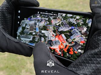
Reveal Farsight Photogrammetry Software
Reveal Farsight Photogrammetry Software
Running on a mobile device or computer/laptop, Farsight from Reveal Technology processes photos, videos or a stream from a drone to create an up-to-date 2D map or 3D model of the area within minutes. The 3D model includes buildings, vehicles, trees and shrubs, and topography.
Farsight will prove useful as a tool for damage/incident documentation and situational awareness in emergency management. The software can also determine helicopter landing zones and analyse the field of view of observers from any point on the map.
Farsight can operate fully locally, without communication with external servers, however, network connectivity allows for integration with the TAK network, in order to make locally generated models available to higher levels of operational command or remote units.
Supported system platforms: Android, iOS, Windows, Linux
BSP compatibility: compatible with most consumer and professional drones, from nano and micro class BSPs to larger designs such as the FlyEye or Bayraktar TB2
Image and video support from visible light cameras: yes
Image and video support from thermal imaging cameras: yes
Option to export models to external systems: yes
Integration with ATAK: yes

Business sector
Hazard analysis and recognition
Protection and security services
Chemical and ecological rescue services
Emergency medical and mountain rescue services
Water rescue services
Brands
Skydio
Atlas Aerospace
Autel
Hoverfly
Reveal