DILECTRO SPÓŁKA Z OGRANICZONĄ ODPOWIEDZIALNOŚCIĄ
- ul. Brukselska 4, 03-973 Warszawa, Poland
- 881726700
- kontakt@dilectro.pl
- dilectro.pl
Description
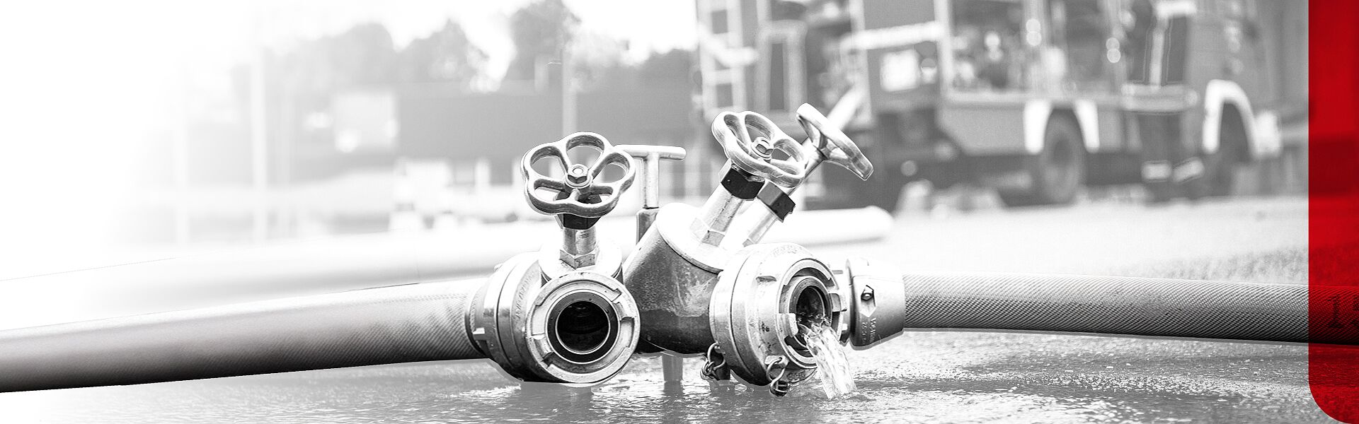
Dilectro Enterprise is a specialised part of Dilectro dedicated to providing drones, anti-drone systems, training, maintenance services and the software needed to integrate them for business and government. We are one of the oldest companies in the country supplying drones to the B2B sector since 2015.


Download
-
Sky-Hero.pngfile size: 877.73 KB
-
Elistair-Khronos.pngfile size: 386.93 KB
-
DIODON-HP30.pngfile size: 746.10 KB
-
Autel-Robotics-EVO-Lite-640T-Enterprise.pngfile size: 310.40 KB
-
Autel-Robotics-Evo-Max-4T.pngfile size: 380.06 KB
Products

AgEagle eBee X
AgEagle eBee X
The eBee X from AgEagle is a flying wing drone that is designed for efficient long-range mapping with high-quality imaging. The eBee X allows for flight operations of up to 90 minutes. On board was an RTK module and a high-quality payload sensor. The drone is operated by one person with easy portability in a dedicated backpack.
1.5 cm imaging accuracy
90 minutes flight time on a single battery
Compatible with 3D, RGB, multispectral and thermal imaging cameras
Weight at only 1.6 kg
Flying wing type design
Shock and impact resistance
Remote ID and compliance with C2 and C6 classes
Low noise emissions
3 minute flight preparation time
Compatible with a wide range of data processing software
Ability to fly in a swarm of 4 drones


Autel Robotics Alpha
Autel Robotics Alpha
Autel Robotics Alpha is a high-end quadrocopter designed specifically for Enterprise customers. The unmanned aircraft, measuring 1205 x 980 x 278 mm, was created for the most demanding and long-lasting missions. The 30-kilometer range and 40-minute flight interval on a single battery set new quality standards in the industry.
Data transmission range of 15 km
40 minutes flight time on a single battery
Weather resistance confirmed by IP55 certification
Built-in system against RFI, EMI, GPS signal interference
Autonomous operation mode
Interchangeable payload modules
AES-256 data encryption
360-degree obstacle avoidance system
Maximum flight speed of 25 m/s (90 km/h)


Autel Robotics Evo Lite 640T Enterprise
Autel Robotics Evo Lite 640T Enterprise
The Autel Robotics EVO Lite 640T Enterprise is a smaller and lighter version of the world-renowned EVO II Dual 640T Enterprise V3. It is currently the smallest and lightest Enterprise-class qudrocopter equipped with a high-end thermal and visible light camera. The drone features state-of-the-art AI, three-axis obstacle avoidance and a battery that allows up to 40 minutes of flight time.
48 MP visible light camera with 1/2” CMOS sensor and
640 x 512 pixel thermal imaging camera with 16x digital zoom
Weighs just 866g
Range of up to 15km
Maximum flight time of up to 40 minutes
Multidirectional obstacle avoidance
Maximum data transmission range up to 12km
Assigned C1 class, flying in A1/A3 category
640 x 512 pixel thermal imaging camera with 16x digital zoom
Weighs just 866g
Range of up to 15km
Maximum flight time of up to 40 minutes
Multidirectional obstacle avoidance
Maximum data transmission range up to 12km
Assigned C1 class, flying in A1/A3 category


Autel Robotics Evo Max 4T
Autel Robotics Evo Max 4T
Reach new frontiers. Autel's newest drone, the EVO MAX 4T, will allow pilots to perform most inspection and SAR missions from the air. A multitude of cameras and sensors, along with intelligent automatic flight systems, makes EVO Max 4T capable of becoming a sensational tool in the industrial sector.
48 MP camera with 10x Optical Zoom and 160x Digital Zoom
Thermal camera with 640 x 512 pixel resolution
Wide angle camera with 50 MP resolution
Laser rangefinder with a range of 1.2km
IP43 protection rating
Flight time up to 42 minutes
Range up to 20km
Multidirectional obstacle avoidance
Compatible with USR RDT G2 software
Compatible with class C2
Thermal camera with 640 x 512 pixel resolution
Wide angle camera with 50 MP resolution
Laser rangefinder with a range of 1.2km
IP43 protection rating
Flight time up to 42 minutes
Range up to 20km
Multidirectional obstacle avoidance
Compatible with USR RDT G2 software
Compatible with class C2


DIODON HP30
DIODON HP30
The DIODON HP30 is a unique inflatable, waterproof unmanned aerial vehicle for flight operations near water. The design, weighing less than 2 kg, is adapted for defense, security and inspection missions in an aquatic environment. DIODON is manufactured from proven components and meets the highest military safety standards
Waterproof and floating on water
High quality thermal and visible light camera
Compliant with military standards
No data storage in the drone
Resistant to interference and mechanical damage
Compact size and weight - belonging to the micro class
Intuitive user interface
Operating time up to 5 hours
Flight time up to 28 minutes
Range up to 8 km
Takeoff/landing from water or ship


FIXAR 007
FIXAR 007
The FIXAR 007 is a fully autonomous hybrid unmanned eVTOL (vertical takeoff and landing) aircraft designed for a variety of missions, including mapping, aerial inspection, imaging, precision agriculture, critical infrastructure monitoring, delivery and more, and more. Compact, lightweight and quick to launch, it provides high agility and performance in urban environments.
Flight distance up to 55 km
Cruising speed of 65 km/h (18 m/s)
Flight time up to 70 minutes (up to 100 minutes in the Long Endurance version)
Preparation for flight in less than 5 minutes
Ability to carry modules weighing up to 2 kg
Flight in wind speeds up to 15 m/s
Maximum flight speed 87 km/h (24 m/s)
Maximum flight altitude of 6115 m (ASL)
Weather resistance confirmed by IP54 certification

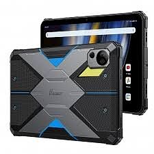
FOSSiBOT DT2
FOSSiBOT DT2
Rugged tablet for service. Unique rugged design with MIL-STD-810H, IP68 and IP69K certifications. On board a large 10.4-inch IPS LCD screen with Full HD resolution and increased maximum brightness. Responsible for performance is a MediaTek Helio G99 processor with as much as 12GB of RAM and 256GB of storage. The tablet features a 4G LTE modem, Wi-Fi 6 and a GPS module with GLONASS and Beidou support.
Rugged construction resistant to mechanical damage
MediaTek Helio G99 processor
12GB of RAM and 256GB of built-in storage
10.4-inch FullHD+ IPS LCD screen
Compliance with MIL-STD-810H, IP68 and IP69K standards
64 MP main camera and 32 MP front camera
Built-in 4G LTE modem, Wi-Fi 6 and Bluetooth 5.0
GPS, GLONASS, Beidou navigation
22,000 mAh battery with 66W fast charging
Android 13 operating system with access to Google services


FOSSiBOT F106 Pro
FOSSiBOT F106 Pro
Affordable rugged smartphone for service. The FOSSiBOT F106 Pro is an extremely rugged design tailored for special tasks. The case is MIL-STD-810G, IP68 and IP69K certified, and the hardware features an extremely powerful 3W flashlight and a programmable function button. The device has NFC for tag reading. A MediaTek Helio G85 processor is responsible for performance, along with 8GB of RAM and 256GB of built-in storage. There was no shortage of a large 12,000mAh battery with fast 30W charging and a 48MP main camera.
Rugged construction resistant to mechanical damage
MediaTek Helio G85 processor
8 GB of RAM and 256 GB of storage
12,000 mAh battery with 30W charging
48 MP main camera and 20 MP camera for night shots
Built-in 3W flashlight
Programmable function button
NFC module for contactless payments
Compliant with MIL-STD-810G, IP68 and IP69K standards
Android 14 operating system with access to Google services


FOSSiBOT F109 5G
FOSSiBOT F109 5G
Rugged service smartphone with 5G connectivity. FOSSiBOT F109 5G combines a rugged, crash-resistant design with modern and powerful components. The smartphone, which is not afraid of dust, dirt, dust, falls, high or low temperatures will perform in all conditions. The model is powered by a modern Dimensity 6300 processor from MediaTek. On board 8 GB of RAM, 256 GB of storage and a 50 MP main camera. Thanks to NFC, contactless payments and tag reading are possible. A programmable secondary button also takes care of comfort and convenience. The device complies with MIL-STD-810G, IP68 and IP69K standards.
Rugged construction resistant to mechanical damage
MediaTek Dimensity 6300 processor
8 GB of RAM and 256 GB of storage
10600 mAh battery with 18W charging
Compliance with IP68 and IP69K standards
50 MP main camera and 5 MP Macro camera
Programmable function button
NFC module for contactless payments
Compliant with MIL-STD-810G, IP68 and IP69K standards
Android 14 operating system with access to Google services


FOSSiBOT F1200
FOSSiBOT F1200
Compact, portable power station equipped with 7 output ports with different connectors. The product is based on a durable LiFePO4 battery that is resistant to temperature spikes. It features a built-in surge protection system and can serve as a UPS. On board built-in extension and connector to connect solar panels.
1024 Wh of battery capacity and 1200 W of operating power
Fast charging from 0 to 80% in just 49 minutes
LiFePO4 battery with a life span of more than 4,000 cycles
7 output ports (2x AC, 1x 12V, 2x USB A, 2x USB C)
4 charging methods (AC/Solar/AC+Solar/Car)
Built-in LCD display for management
Built-in LED lighting and SOS indication
UPS emergency power supply function
BMS surge protection mechanism
Carrying handles
Weight 11.5 kg


FOSSiBOT F2400
FOSSiBOT F2400
Portable power station equipped with 13 output ports with various connectors. The product is based on a durable LiFePO4 battery that is resistant to temperature spikes. It features a built-in surge protection system and can serve as a UPS. On board built-in extension and connector to connect solar panels.
2048 Wh of battery capacity and 2400 W of operating power
Fast charging from 0 to 100% in just 90 minutes
LiFePO4 battery with a life span of more than 3,500 cycles
13 output ports (3x AC, 4x 12 V, 2x USB A, 4x USB C)
Built-in LCD display for management
Dedicated mobile app for station control
Built-in LED lighting and SOS signaling
UPS emergency power supply function
BMS surge protection mechanism
Carrying handles
Weight 22 kg


GUIDE PR410
GUIDE PR410
Guide PR410 is a dual-function thermal imaging camera designed for use in rescue and search operations. The high quality sensor, large display, weatherproof housing and many features support fast and effective reconnaissance, fire and missing persons localization, which influences efficient search and rescue and firefighting operations. Guide PR410 is the ideal solution for efficient and fast operations with thermal imaging technology.
Resolution: 384 x 288 pixels @12μm
Detector type: VOx, 7.5 to 14μm
Frame rate: 30Hz
Field of view: 50°×37°
Operating temperature range: Auto-switching support: -20°C to 150°C, 0°C to 650°C, optional 500°C to 2000°C
Built-in 4.3-inch screen with 800 x 480 pixel resolution
Six operating modes
128 GB of built-in storage
4 hours of battery life
Weatherproof
36-month manufacturer's warranty


GUIDE PR610
GUIDE PR610
Guide PR610 is a dual-function thermal imaging camera designed for use in rescue and search operations. The high quality sensor, large display, weatherproof housing and multiple functions support fast and effective reconnaissance, fire and missing persons localization, which influences efficient search and rescue and firefighting operations. Guide PR610 is the ideal solution for efficient and fast operations with thermal imaging technology.
Resolution: 640 x 480 pixels @12μm
Detector type: VOx, 7.5 to 14μm
Refresh rate: 30Hz
Field of view: 50°×37°
Operating temperature range: Auto-switching support: -20°C to 150°C, 0°C to 650°C, optional 500°C to 2000°C
Built-in 4.3-inch screen with 800 x 480 pixel resolution
Six operating modes
128 GB of built-in storage
4 hours of battery life
Weatherproof
36-month manufacturer's warranty


Sky-Hero Loki MK2
Sky-Hero Loki MK2
The Sky Hero Loki MK 2 enables military personnel and police officers to gather key information about immediate threats before entering confined and hard-to-reach areas. With extreme performance in most lighting conditions, the camera allows users to observe a target even in zero light. Minimal latency and a guarantee of no frozen images enable reliable and fast situational awareness for precise decision-making.
Flight time up to 15 minutes
AES-256 encrypted transmission
Analog video transmission
IR LEDs for operation in the dark
Control 4 drones with 1 controller
Possibility to connect bang charges
Impact and drop resistant
Precise position maintenance without GPS network
AES-256 encrypted transmission
Analog video transmission
IR LEDs for operation in the dark
Control 4 drones with 1 controller
Possibility to connect bang charges
Impact and drop resistant
Precise position maintenance without GPS network


Sky-Hero Sigyn MKI
Sky-Hero Sigyn MKI
The Sigyn robot is an addition to Sky-Hero's portfolio of pocket-sized, lightweight, throwable ground robots specifically designed to collect and transmit real-time audio/video information with remarkable ease and simplicity of use.
Designed and manufactured in Europe with best-in-class materials, this small robot withstands heavy use and provides reliable situational awareness from hard-to-reach and dangerous locations.
Driving time up to 120 minutes
Stand-by time up to 300 minutes
Video range: up to 150m
2 EO/IR cameras and HD microphone
Power supply 2x Li-Ion 3000mAh
Driving speed: 1.7m/s
Weight: 1150g and lifting capacity: 2kg
Resistant to impacts and falls from 6 meters
Ability to control 4 devices from 1 GCS controller
Stand-by time up to 300 minutes
Video range: up to 150m
2 EO/IR cameras and HD microphone
Power supply 2x Li-Ion 3000mAh
Driving speed: 1.7m/s
Weight: 1150g and lifting capacity: 2kg
Resistant to impacts and falls from 6 meters
Ability to control 4 devices from 1 GCS controller


USR FIRETRAK
USR FIRETRAK
Firetrak software is used to support forest firefighting activities. The solution allows effective analysis of images acquired from a drone to identify the source of a fire and to manage the process of extinguishing forest fires. It is the world's first program to support forest firefighting operations using the potential of unmanned aerial vehicles.
Determination of forces and resources needed to extinguish forest fires
Identification of the number of firebreaks
Map of places requiring firefighting
Compatible with Microsoft Windows operating system
Works in offline mode
Identification of the number of firebreaks
Map of places requiring firefighting
Compatible with Microsoft Windows operating system
Works in offline mode

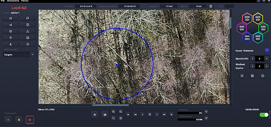
USR Loc8
USR Loc8
Loc8 is a revolutionary software developed by USR that enables the rapid processing of thousands of images in a short period of time. The program uses advanced image scanning technology to isolate specific clusters of pixels and identify potential targets. The solution works well for processing images acquired from UAVs in search and rescue operations - for finding people, animals and targets.
Advanced detection of objects from images based on the color band
Precise GPS coordinates of located targets
Scanning of multiple objects at the same time
Detailed situation report
Easy import of mission images
Short calculation time
Offline operation
Windows and macOS compatibility
Precise GPS coordinates of located targets
Scanning of multiple objects at the same time
Detailed situation report
Easy import of mission images
Short calculation time
Offline operation
Windows and macOS compatibility


USR RDT
USR RDT
RDT software is used to support search and rescue operations by automating the process of analyzing a large number of thermal images acquired from a drone. Manually reviewing such a volume of images can be a time-consuming task, even if there are no time constraints. The added time pressure in search and rescue missions, for example, can affect the risk of error. The program will help us minimize the margin of error and successfully complete operations in a faster time.
Automatic indication of the hottest pixels
Selection of temperature range to be detected
Sorting and export of processed images
No limitation on the number of processed images
Graphical representation of the number of images.
Configuration of the temperature range of the searched objects
Automatic selection of images with the sought temperature range (heat pixel)
Automatic marking of objects
Analysis of images based on the radiometric chart
Short calculation time
Offline operation
Compatibility with Windows 10/11 operating systems
Indication on the satellite map of the place where the photo was taken
Report generation
Software in Polish language version

Brands
Autel Robotics
Parrot
AgEagle
Diodon
Elistair
ARASTELLE
Guide
Sky Hero